Posts

Showing posts from October, 2016

Autumn walk in the (national) park - Biogradska gora

Image
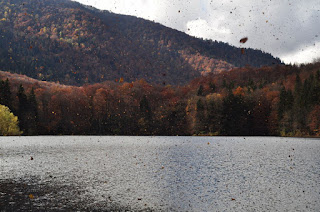
This is not strictly a hike, more like a long drive and mini-walk. But autumn in this national park is spectacular because of the diversity of trees and the colours of the leaves. Every day gives you a different combination of sunlight, clouds and foliage, and I was on this occasion treated to strong winds which suddenly blew a cloud of leaves over the lake, as if caught in a locust swarm. The entrance fee to the national park is €3 and it is accessible from the main Podgorica-Bijelo Polje road, north of Kolasin. Construction is ongoing on a restaurant (if was ongoing last year at the same time) by the lake, and the souvenir shop was closed

Bandijerna Peak (2,409m)

Image
Four weeks after the last attempt was thwarted by rain, I finally returned to this peak, close to Durmitor's highest (Bobotov kuk) and right in between the jagged edge of Zupci and Sljeme. Despite being higher than Prutas, the walk to this peak is relatively short from the parking area at Sedlo, on the Virak-Trsa road. There was still snow on the north-facing and shaded spots, but nothing too concerning. The path was very muddy and slippery from the thawing snow, but once we got off the path onto the rocks the going was easier. There is no marked path except the path to Zeleni Vir and Bobotov kuk, but, as visibility was good this time, we were able to veer off and head towards Trojni prevoj (Three-way Pass). It seems there are piled stones on some of the rocks to indicate roughly the right way, but it was no problem just heading towards where I knew we had to go. From Trojni prevoj we headed straight up the mountain from where we were rewarded with a beautiful 360 degr

Šarena Lastva (nr. Mt. Maglić) 2228m

Image
I had been planning for the whole year, and in fact for the last 13 years to do a hike to Lake Trnovac in the Piva region. It seemed like the days were getting too short to be able to do such an epic hike, but we set off from Nikšić early in the morning towards the village of Mratinje. Despite my usually trusty car temporarily conking out on the way, we made it as far as we could go along the macadam road past Mratinje to a village I think is called Čair or Ćalasani. After some helpful advice from a friendly local, we followed the clear trail markers from the low cloud and autumnal colours, eventually through the mist and above the clouds and into snow, which had fallen the previous day. With frequent digging to find the buried markers, we made our way ever upwards, mindful of the need to get back before dusk. At one point we realised that uncovering the trail markers was using up valuable time, so we headed towards what seemed to be a promising peak through 20cm of snow,

Mrtvica Canyon (slightly amended route)

Image
Firstly, just to say that I haven't included a picture of the more famous parts of the actual canyon, because this is about my tenth time to hike it and so I didn't take many photos. What was different this time is that we took a route that went on the left side of the river, rather than the more usual right bank. The starting point is about 40 minutes north of Podgorica on the main road to Kolasin. There is one asphalt road with signposts for Mrtvica Canyon and the village of Mrtvo Duboko, but we took the road leading to the village of Velje Duboko and parked almost immediately. One path leads across an iron bridge where we joined the asphalt road towards the village of Mrtvo Duboko, past several beautifully constructed houses, then down to a bridge made of thin planks, and further on to the bridge pictured above. Then we joined the familiar path along the canyon itself. For those reading who have never seen the canyon, it is breathtaking in its proportions. It is