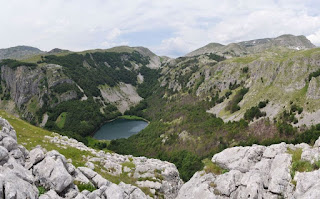
Climb up Maganik (2,001 m)
One of the greatest barriers to climbing this mountain was access along the roads beyond the quarries, and working out which of many unmarked roads to take to get to the start of the walk, a shepherds’ settlement called Rekočica katun, although it would have been a better choice to continue another couple of kilometres to the katun of Maganik, which has a more clearly marked trail. Needless to say we lost any semblance of a trail and oriented ourselves by means of compass and instinct, arriving at a pass with a large rocky pavement with deep cuts between the flat karst “paving slabs”.
In front of us the valley where the village of Velje Duboko lies was just about visible in the distance, with the Mrtvica Canyon leading off to the right side. View towards the Mrtvica Canyon
We turned right along the ridge which appeared to lead to Babin Zub (the location of a plane crash in the seventies). The going was difficult because the rock had so many crevasses, which required climbed down and up again, or changing route to avoid wider cracks. It happened to be the hottest weekend of the year, and we had rather too little water for those conditions, and we decided to stop short of the highest peak, settling for the near-by Kokotov peak, a still respectable 2,001 m above sea level, a total climb of around 500 m (the highest peak, Međedi vrh is 2,138 m).
Babin zub peak
The
descent along a marked trail was a much easier route than the one we
had conjured on the way up, and we were soon in Maganik katun, where
fortunately we were able to get some water from shepherds. This mountain
is significantly different from the other massifs visible from the top,
much more like Orjen in terms of sharp karst rocks with lots of cracks,
little water and only sparse vegetation on the exposed higher areas.


Comments
Post a Comment