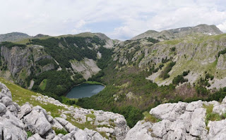
Komarnica Canyon
This relatively easy walk can be done in several variants, all of which will be detailed here, although this time I am recording the second walk along this canyon, not wishing to duplicate blogs on the same trail. The River Komarnica starts in Durmitor near Sedlo, flowing down this canyon – in the summer it is largely dry or else underground, whereas during the spring the flow is at its most powerful, and there are several waterfalls either along its course or from streams feeding into it as the descend into the canyon. The canyon is dominated on one side by a 15-km-long almost vertical wall of rock called Boljske grede, while on the other side the incline is gentler and almost completely covered in trees. The canyon widens out at the village of Komarnica, where there is road access. After several kilometres of dirt track, asphalt begins and the River Komarnica is joined by the River Grabovica which pours down one side of the canyon making a spectacular waterfall called Skakavica. These waters flow into the Nevidio Canyon, well known to extreme sports enthusiasts in Montenegro for the tricky (and expensive) traversal of this canyon which is in places so narrow you have to squeeze through. The first time I explored the Komarnica Canyon (northwards from Nevidio), I drove to the end of the road and went as far as I could in the time I had, and then returned. This time, we were dropped off by taxi at the north end in Durmitor at Šarban (near Dobri Do) and walked downhill all the way to near the beginning of the Nevidio Canyon, some 15 km. One of the features of the canyon is the different terrain – rocky ground, fir forest, flowing water, wider fields sandwiched between the canyon walls, the more deciduous woods further downstream. In a few places you have to cross the river and streams: fortunately some rocks have been deposited as stepping stones.


Comments
Post a Comment