Posts

Mt. Stožina in the snow (1,905 m)

Image
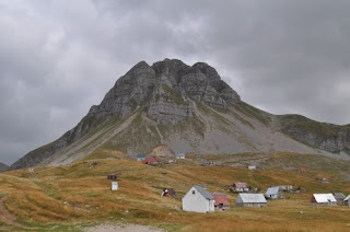
The winter has been very mild even in Žabljak, such that the first kilometre of the ring road around Durmitor from the turn-off from the main road to Sedlo was open to cars. The walk from Pošćenski kraj to Sedlo is not very long, so the decision was made to try to climb Stožina, a dramatic-looking hill right next to the road that I had climbed during the late spring of 2015. Once off the road, the snow was quite deep in parts where it had drifted, but still rocks protruded in places. The climb was too steep for snowshoes, but crampons were perfect for the consistency of snow. Much of the hill is grassy terrain, so there was good grip almost all the way up. There was one tricky part two thirds of the way up, where it was very steep and there were many rocks, so in places the crampons were not helpful, in others the snow was very deep in between rocks and we were up past our knees in snow drifts. It took just over an hour to climb, but at the top the wind was bitter, snow s...

Borovnik hike (1,930m)

Image
The road from Nikšić to Bare Bojovića, the area in front of Mts. Žurim, is notoriously blocked by snowdrifts until April most years. However, one can often get as far as the start of the Konjsko plateau (which is also accessible by foot from Vučje ski centre). As the winter had been very mild, we managed to get to this point (although we spent about an hour digging the jeep out of snow) and set off on snowshoes for Mt. Borovnik. The snow was very deep and even with snowshoes it was quite tough going, especially on the steeper sections. We ultimately didn’t have enough time to reach the main peak (because of getting the car stuck in snow) and were able to descend without snowshoes, by clambering over exposed rock and wading through the areas of snow where we had climbed up. The vista from the top was beautiful, as it contained the plateau that we had crossed, the Krnovo plain across which we had views towards Mt. Vojnik, with the peaks of Durmitor glistening in the distanc...

Šljeme (East summit) 2,445 m - last hike before winter

Image
The weather afforded us one last sunny weekend before the snow was due to hit Žabljak, although it was blustery and cold. Parking at the ski centre at Savin kuk, we took a gently rising path around the foothills westwards through woodland, past Šupljika in the direction of the road to Sedlo. Then we found a protected steep grassy slope going up to the ridge Zupci.  This ridge gradually rose all the way to Šljeme. We calculated that we would not have enough time to reach the highest peak, so settled for the eastern summit, which affords a view towards Međed northwards and to Bobotov kuk north-eastwards.  It was bitingly cold with a stiff breeze here, so after a brief stay at the summit, we headed back towards Čista strana and then back to the ski centre. This was a physically challenging climb, but very satisfying because of the excellent views over most of the main peaks and features of Durmitor. At 2,445 m the eastern summit is still one of the highest peaks, w...

Stožac hike (2,141 m)

Image
During the summer the macadam/dirt track to Lake Kapetanovo is accessible, although a car with high clearance is recommended because of rocks on the road. The walk from the start of this road, if one decides to park there, to the lake across the valley (not along the road which snakes through the mountains) is about 1 hr 20 min and is a pleasant enough walk. The path from Lake Kapetanovo at the south-west side of the lake rises steeply to a rocky and stony pass, from where a goat trail up to the right leads over another pass to a mass of rock, intercut with deep cracks some of which contain snow. Following the line of the ridge on the left brings you to a grassy area where the peak of Stozac comes into sight, as does the more interesting rocky outcrop, Ilin vrh (Elijah’s peak) which is slightly lower. There are some other peaks further on which afford a great view of Lake Manito and Lake Kapetanovo and a steep descent, although tricky with slippery grass down to Lake Mani...

Mali Žurim climb (1,965 m)

Image
Of the two peaks called Žurim – the shorter, Mali Žurim, is the more interesting to look at and climb. The taller, more massive Veliki Žurim is less dramatic, easier to climb, but the benefit is that from its peak you have an excellent view of its little brother. Mali Žurim consists of a steep, flattened cone with three distinct sharp peaks which separate just below the summits. The easiest way to climb is to the right-hand side, as you approach from the road from Bare Bojovića, going up a stony, zigzagging path to a pass which leads towards Ilin vrh, a peak further to the right. From this point just before the pass, looking up high to the left, there is a red arrow painted onto a rock near the top of the mountain, although this is very hard to spot unless you know it is there. The slope has a lot of movable material, but there are grassy parts which provide more stable footing. The rocky peak requires some clambering, but is not dangerous on that side. We decided to clim...

Mt Prutas (2,391 m)

This wasn’t my first climb up Prutas, in fact it was possibly my third; however, this was my first climb from the spring Sarban, which as it turns out is a relatively short route (which means almost straight up!). August is not a sensible month to be climbing such a mountain which has no trees, however this is a yearly event supported by the Montenegrin Army and the Municipality of Pluzine, which provide bean stew and beer, and of course company. The ascent is unrelenting in intensity, but it is by no means unattractive. From the top there is a wonderful 360 degree view, with a lovely view over the Susica Canyon, which leads to Lake Susica (which is a great walk for summer months, because there is plenty of overgrowth). We came down via the pass of Skrcko zdrijelo, down to the road through Urdeni do, but it was a long distance along the road back to the start place, so we were fortunate to be able hitchhike the remainder of the walk, which would have taken over an hour.

Climb up Maganik (2,001 m)

Image
One of the greatest barriers to climbing this mountain was access along the roads beyond the quarries, and working out which of many unmarked roads to take to get to the start of the walk, a shepherds’ settlement called Rekočica katun, although it would have been a better choice to continue another couple of kilometres to the katun of Maganik, which has a more clearly marked trail. Needless to say we lost any semblance of a trail and oriented ourselves by means of compass and instinct, arriving at a pass with a large rocky pavement with deep cuts between the flat karst “paving slabs”.  In front of us the valley where the village of Velje Duboko lies was just about visible in the distance, with the Mrtvica Canyon leading off to the right side.  View towards the Mrtvica Canyon We turned right along the ridge which appeared to lead to Babin Zub (the location of a plane crash in the seventies). The going was difficult because the rock had so many crevasses, which req...