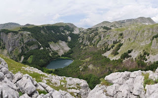
Mt Vrsta, Piva
The Piva Mountains represent a less well known attraction for hikers, partly because it is not (yet) a national park – currently it has been characterised as a nature park, but doesn’t have the sort of funding that the five national parks have. Despite this, there is now good signposting to the main attractions. The highest peak is Maglić, on the border with Republika Srpska. These mountains can be accessed in various different parts, mainly near the town of Plužine, the municipal capital. Mount Vrsta lies among the northernmost clumps of mountains and is best accessed from the village of Ćalasani: after arriving in Plužine from the south, drive along the main road further until the hydroelectric dam, where, after crossing the dam, there is a left turn through a tunnel to the village of Mratinje. There is a signpost to Maglić and Trnovačko jezero at a t-junction, left. We parked at the end of the road near where a spring emerges and flows over the road.
The first part of the walk, which is the same path as for Maglić, Lake Trnovac and Trnovački Durmitor, is an almost unbroken climb, firstly through deciduous forest, then over a stony terrain. After about two hours you arrive at another signpost at the spot called Presjeka. For Vrsta you turn left, and for all other routes, right. Mt Vrsta is the peak on the left that you can see for all of the walk, and here you have to, by and large, pick your own route, although there are stone cairns if you can spot them that are presumably used by shepherds in foggy conditions. After 4 hours of what seems like unending climbing, you are rewarded with a view over the entire region – especially towards the Piva Canyon, and Durmitor behind it. Mratinje Lake is visible below, which you would certainly miss on the climb because it is hidden by the trees. The return is along the same route.


Comments
Post a Comment