Posts

River Grabovica 8 & 23 March
Image
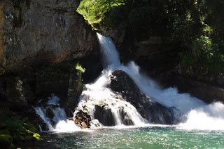
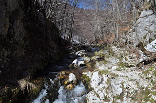
These two hikes were explorations of the River Grabovica which flows into the River Komarnica via the Skakavica Waterfall, which is visible from and very close to the road that leads to Komarnica, just before the parking for Nevidio Canyon. There are trail markers to the right side of the gulch leading from the waterfall, which take you upwards on a winding path. There are frequent views down onto the waterfall and the river that feeds it. With some difficulty you can get closer to the river at one part where the flow narrows and plunges downwards. If you have nerves of steel you can jump across the river here for a nice view. The canyon is not accessible upstream from here, at least it wasn’t in spring when the flow is strongest. We climbed up towards the main Savnik-Zabljak road, and walked about 200 metres along it until we found a turn-off which leads down back to the river along a stony track. The river is shallow enough to cross here (barefoot or with waterproof boots, although p...
Pestingrad/Djerinski vrh

Image
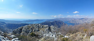
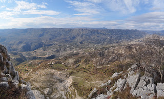
  Although I had hiked part of this trail before when I explored the mountains above Kotor, walking from Kotor to Krstac and then along an Austro-Hungarian road to Zalazi and then down to Sveti Stasije, I had not climbed up to a famous viewpoint called Pestingrad, which is very close to Krstac. Since the coastal mountains are snow-free most of the year, this was an ideal time to explore, rather than the middle of summer (when I last walked there) with temperatures into the thirties. The path was very easy to find and follow from the restaurant right next to the road, near to the entrance to Njegusi. We got a little lost at one point but refound the trail, and then when Pestingrad came into sight (there is a path down to the left, as you face Kotor, which leads to the hill of Pestingrad), however, we decided instead to climb the higher peak of Đerinski vrh and were able to take a shortcut down on the Krstac side. It was a fairly short hike, but with lots of scrambling up rocky slope...

Ostroške grede

Image
The start of the trail, at an altitude of 800 m, is located at the northern end of the overflow car park near the Ostrog Upper Monastery. It climbs northwards fairly gently through forest and it takes about one and a half hours to get to the peak of Ostroske grede – Uroseva glavica at 1,154 m and the whole hike was 9 km there and back. The scenery on the way up is very dominated by limestone rocks and bushes overlooking the Zeta Valley, but there is a wide view including Glava Zete, crisscrossed by winding, thin roads. From the top, one can see Niksic Plain to the north-west and the Moraca Mountains and beyond to the north-east. One of the easiest hikes.

Maglić (from the Montenegrin side)

Image
This climb was definitely the highlight of my mountaineering year! As with the climbs of Trnovački Durmitor and Vrsta earlier documented on this blog, we started from the village of Ćalasani, accessed from a left turn after crossing the Piva hydroelectric dam from Plužine, through Mratinje, as far as you can get by road. I have to emphasise at the outset that this walk is almost completely uphill all the way until the peak of Maglić, but has a wonderful range of different terrain – woodland, which is incredible during the mid-to-late autumn, then bare rocks, then grass, and you are rewarded with great views of Lake Trnovac. The time estimates on the signposts do not include breaks! The GPS data from my phone informs me that, while the journey to the peak took us just over 3 hours not counting breaks, it was more like 6 hours including breaks. Given the fact that the elevation gain is from 985m to 2,336m, i.e. lots, this is not surprising. Overall, we took over 11 hours fo...

Sušica Canyon walk

Image
 This canyon walk is a good summertime walk because about half of it is through woodland. There is room to park on the road from the village of Nedajno towards Mala Crna Gora, at the bottom of the canyon, where there is a mountain lodge, where during the summer there is often a park ranger issuing tickets for Durmitor National Park (and perhaps charging for parking), although he was actually at the lodge by Lake Škrka (the other end of the canyon) when we walked. There is also a spring here where you can fill up with cold water. The walk starts from Lake Sušica, leading along its west shore (the eastern side is just rocks, and is hard on the ankles) and then along the canyon, mainly keeping the River Sušica on the left side. During the summer, this river largely dries up (presumably the reason for the river’s name). There is one large clearing that is full of nettles, but this seems now to be cleared during the tourist months, so long trousers are no longer essential f...

Gornja Bijela waterfall

Image
Although Gornja Bijela is accessible by road from the main road from Nikšić to Žabljak near the village of Kruševice, where there is a turn on the right as you head northwards, there is a pleasant walk also from the Krnovo Plain from the last of the windmills along this valley, which leads westwards where there is a break in the long line of mountains. The trail leads downwards along a stream, largely surrounded by trees. The road comes out onto the left side of a valley which points towards Šavnik. From here you need to find a path which continues downhill, rather than along the road which follows the contours of the valley. The path goes past a couple of houses, and follows a stream, eventually coming out onto the asphalt road mentioned earlier. Here your ears can lead you to the River Bijela, and follow this upstream to where the waterfall is. This is a beautiful spot, and as the summer goes on the flows slightly diminishes. The return trip is almost completely uphill.

Stabna Lakes

Image
The village of Stabna is accessible from Plužine along an asphalt road which hugs the western leg of Lake Piva. There is a left turn which further west and upwards, until a sharp dogleg takes you up towards Stabna. There are signposts to the end of the road, which eventually stops being asphalt when you take a left fork. The end of the road is marked by a chain across the path preventing further progress. The trail is marked from here all the way up to the two lakes, firstly Small Stabna Lake and then Large Stabna Lake. This is almost all in the woods, with the exception for around the two lakes. Take care at the far end of the small lake, where there are lots of boulders and a stream flows into the lake, as snakes bask here during the summer and frequently cross the trail. The larger lake is more frequented by frogs than snakes and makes an excellent spot for lunch. We decided to head right in the direction of Mt. Bioc, and after a climb of about 50 metres there is a spr...